
Spatial Analytics: Unlock Insights Through Location Data
Spatial analytics is the process of examining location-based data to uncover patterns, trends, and relationships that might not be evident otherwise. By integrating geographical information with traditional data sources, businesses and organisations can make more informed decisions. Whether it’s optimising supply chains, improving customer targeting, or enhancing urban planning, spatial analytics provides actionable insights that drive efficiency and innovation. With advancements in technology, such as Geographic Information Systems (GIS) and real-time data collection, spatial analytics has become more accessible and impactful across a wide range of industries. Embrace the power of spatial analytics to transform data into meaningful strategies tailored to your specific goals.

GEO AI
Geo AI (Geospatial Artificial Intelligence) is the combination of geospatial data (location-based data) with artificial intelligence (AI) techniques like machine learning and deep learning to analyze, predict, and understand geographic patterns, relationships, and trends.Geo AI = Geographic data + AI algorithms.
Satellite Imagery, GPS Data, Remote sensing data, maps and spatial databases and sensor data( e.g drones) can be used with GeoAI. AI techniques can detect
-
Detect patterns (e.g., land use changes, deforestation, urban sprawl)
-
Classify objects (e.g., identifying buildings, roads, crops in images)
-
Predict events (e.g., flooding, traffic congestion, crop yields)
-
Optimize routes or spatial layouts (e.g., logistics, emergency services)
-
Monitor environmental or urban trends over time
GeoAI can be used in
-
Disaster Response: AI analyzes satellite imagery after a hurricane to identify damaged areas.
-
Agriculture: Predicting crop health using drone imagery and weather data.
-
Urban Planning: Monitoring urban expansion or traffic patterns using spatial data.
-
Climate Change: Tracking deforestation or glacier melt over time with satellite data and AI.
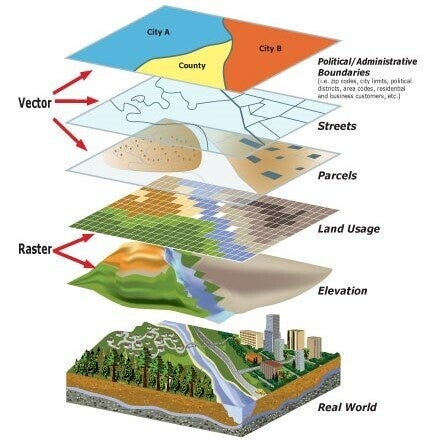
GIS Modeling: Transforming Data into Actionable Insights
GIS Modeling is an advanced technique used to analyse spatial data and create representations of the real world. By leveraging Geographic Information Systems (GIS), this process enables users to simulate, visualise, and predict real-world scenarios across various industries. Whether it’s urban planning, environmental management, or disaster risk assessment, GIS modeling helps decision-makers uncover patterns, solve problems, and make data-driven decisions. With its ability to integrate diverse datasets, such as satellite imagery, topographic maps, and demographic statistics, GIS modeling is a powerful tool that bridges the gap between raw data and practical applications. As technology evolves, GIS modeling continues to innovate, offering more precise and scalable solutions for complex challenges in today’s world.